Saturday 15 December 2018

Finalising 'access only' back streets in Kennington


Over the past decades Lambeth has gradually prevented traffic cutting through many of Kennington's back streets above the Oval. All the areas in pink (such as the Ethelred Estate, Cottington Estate, Walcot Square) are 'access only' for motor vehicles through a mixture of gates, bollards, road closures and one-way workings. This reduces traffic noise, air pollution and road danger in these areas - and has resulted in more local people walking, cycling and using public transport.

However most primary schools are on streets that are not 'access only'. The pupils are exposed to air pollution and deterred from active travel. It is feasible, effective and affordable (using a few gates and bollards) to encompass Archbishop Sumner's,  St Mark's, Henry Fawcett and Walnut Tree Walk primary schools within the 'access only' areas. There are sufficient main roads for through motor traffic to use, without preventing motor traffic reaching properties.

In order of priority:
Archbishop Sumner's Primary School (blue marker just to the right of Kennington Road)
This is the most straightforward to resolve - a gate installed outside the former Court House Tavern on Renfrew Road would mean vehicles have turning spaces whilst through-traffic is stopped.


St Mark's School (blue marker to left of Oval Cricket Ground)
A gate on Kennington Oval at the junction with Harleyford Rd would allow an improved crossing to the cycle superhighway as well as cutting out the rat-running motor traffic, which can still enter and exit (albeit from the Vauxhall direction only, without a sign change) at the other end of the cricket ground. 

Henry Fawcett School (blue marker to the right of the Oval Cricket Ground)
This suffers from traffic cutting through in large part to go down Magee Street and turn left, since TfL banned traffic from turning left at the bottom of Kennington Road (which, given appropriate traffic light design, could be reinstated in my opinion). Magee Street could be closed by Kennington Park Road, with a no-left turn at the end of Bowling Green Street which has the school entrance. This would mean traffic wanting to turn left, if TfL wouldn't review the Kennington Rd turn, would have to use Clayton Street, onto Kennington Oval, Harleyford Street, then left into Kennington Park Road.

Walnut Tree Walk Primary School (top left blue marker)
Installing the gate on Renfrew Road is likely to reduce traffic on this side of Kennington Road too, but if not, two gates on Lambeth Walk will cut out through traffic whilst still permitting access and turning. I have left Lambeth High Street open as it is now and retained access to and from both Black Prince Road and Lambeth Road for the fire station, police headquarters and businesses including Pimlico Plumbers and others who use the railway arches.

Vauxhall Street past Vauxhall primary school has quite low traffic volumes, but these could, if desired, be further reduced with a gate south of Newburn Street, marked in green.

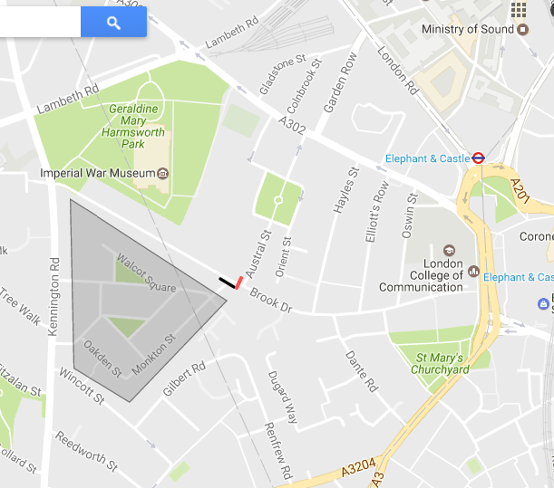
Additionally, a gate, also marked in green, on Brook Drive would cut down the limited west-east traffic cutting through


SOUTH OF THE OVAL

The triangle bounded by A roads south of Harleyford Road / the Oval has some long established 'access only' areas. Four new gates would prevent all rat-running through these back streets: as shown below on Fentiman Road, Dorset Road, Bolney Street and Albert Square.


Friday 17 March 2017

Danger at Hercules Road / Lambeth Road


 On the way to lunch in the Corner Cafe at the junction of Hercules Road and Lambeth Road today, I pointed out to a colleague the lack of any lights for pedestrians wanting to cross Hercules Road. I took a quick photo, little expecting just two hours later to see a pedestrian who was trying to cross here come as close to being run over by a skip lorry as I ever want to see.
We were waiting on our bikes for the lights, below, to turn green so we could exit Hercules Road. A man wanted to cross Hercules Road from the pavement on our right
 With no pedestrian lights to guide him,  after a puzzled look around he started hesitantly to walk out. The skip lorry meanwhile was straddling the lanes on Lambeth Road (below) and the driver swung left into the road past the pedestrian who jolted to a stop just in the nick of time at a shouted warning from another pedestrian.
While the skip lorry driver, in my opinion, took the corner too quickly to allow for pedestrians, I can see how he may have presumed, given a left hand turn lane and a green traffic light, that pedestrians would be faced with their red light to deter them from attempting to cross when the driver was permitted to turn. Given that people do make mistakes and a lot of commercial traffic turns here, having lights guiding pedestrians as to when they can safely cross is a no-brainer.

The pedestrian retreated to the pavement. His second attempt to cross, when the traffic light went red didn't work either because, as he was thinking about stepping out, traffic started flowing out of Hercules Road having got the green light.

For all I know he may still be there. Looking at the photo above, you can see there is no crossing provided across Lambeth Road at this side of the junction. A child or adult walking along the left pavement of Lambeth Road is provided with no other option here than to hazard a guess at the traffic lights phasing and try to get across - and only then do they have a safely controlled point to cross Lambeth Road.

I very much hope that this hazard will be addressed as part of the Quietway that will run from Hercules Road to Sail Street. It certainly needs to be addressed to support the Mayor of London's and Lambeth Council's Healthy Streets agenda.

Thursday 23 February 2017

Proposed text for a CLIP survey response

If you live, work, or visit north Lambeth, please respond to the survey on how Lambeth could spend money from new developments in the area at https://www.lambeth.gov.uk/consultations/consultation-on-community-priorities-for-the-north-lambeth-area-princes-and-oval-wards by Friday 24 February at 11pm

My suggestions for you to copy and paste into the appropriate boxes, including links to detailed proposals:

Project One
Ward: Prince’s
Type of Project: Transport and Streets
Location: The cell of back streets in the Brook Drive area bordered by A roads
Description:  Lambeth, Southwark and TfL cooperate to make changes so that drivers use the main road network instead of rat-running through the residential back streets of this neighbourhood, while retaining vehicle access to all properties, as outlined at http://kenningtonhealthystreets.blogspot.co.uk/2017/02/brook-drive-neighbourhood-proposal.html

Project Two
Ward: Prince’s
Type of Project: Greening, Parks and Local Open Space
Location: Cotton Gardens, Cottington Street, Othello Close
Housing Estate: Cotton Gardens
Description:  A good quality walking and cycling link between Reedworth Street and Kennington Station as described at http://kenningtonhealthystreets.blogspot.co.uk/2017/02/better-walking-and-cycling-options.html

Project Three
Ward: Prince’s
Type of Project: Greening, Parks and Local Open Space
Location: Cottington Close Estate, Knights Walk and Dugard Way
Housing Estate: Cottington Close Estate, Knights Walk and Dugard Way

Description:  Providing an improved walking and child-friendly cycle route linking Kennington to Walworth as described at http://kenningtonhealthystreets.blogspot.co.uk/2017/02/better-walking-and-cycling-options.html

Better walking and cycling options between Kennington and Walworth

Kennington Road, Kennington Lane and Kennington Park Road are major roads that make active travel difficult - especially cycling - on an east-west axis. There are no child-friendly cycle options, due in part to the need to turn onto the main road then turn off it to cross it. 

The map below shows, in black lines, existing walking and cycle routes, and, in purple lines, prospective routes, with blue lines marking the light controlled pedestrian or toucan crossings.

Zooming into, the lower route below, linking Reedworth Street to Braganza Street, requires comparatively little work to bring it to life, while the higher route would fit in nicely to the planned Knights Walk development and the recent creation of a cycling and walking route through Dugard Way to Brook Drive:

Taking the lower route first, suggested easy and cheap changes - from the Reedworth Street end - are:
A) Tweak the barrier to the Cotton Gardens tower blocks car park to make it easy to cycle (including hand cycles and cargo cycles) and walk  through
 Removing the barrier in the road and put the pavement bollard on the edge of the pavement.


B) Make cycle friendly gap in the speed bump
C) Create a more welcoming gap in the wall by the tree and improve the surfacing
 or, probably better, move the gap in the wall to allow passage straight onto the pedestrian crossing (which in a large budget world would be made a Toucan crossing and moved south a few metres to the current gap to align with the wide pavement on Cottington Street!)

 D) make this section of pavement shared space or provide a cycle track (and move the bin in line with the bollards)
A flush kerb to allow cyclists to cross Kennington Lane into the existing gap in the wall would be great.
 D) Cyclists can rejoin the road here, or this section could be made shared use or have a cycle track

F) Provide flush kerbs at the pavement linking Cottington Street and Othello Street
G) Make cycle friendly gaps in the speed bumps on Othello Street
G) Make the pavement on Kennington Park Road to the lights at Braganza Street a shared pedestrian/cycle space, with toucan crossings into Braganza Street.

Taking the upper route through the Cottington Close Estate and Knights Walk:
A) The Guiness Trust Estate (below left) could be used to access Penton Place in Southwark
 The Pedestrian crossing outside Tesco could be moved up to here, to allow a crossing direct to the Cottington Close estate (above right)
 B) Having passed through the arch, the Cottington Close Estate has the view below, but this could be redone to meet the desire line to the exit on the other side of the parking and park space

 C) The pavement on the Kennington Lane exit side is too narrow to have any use. This whole area could be made more pleasant and less car fixated.

 D) A Zebra crossing could be provided, or the existing crossing up towards Jewson, which is not best placed, could be moved down to provide a direct link to Knights Walk.
E) Improvements could be made to what was described in the planning application for flats in Dugard Way as a 'high quality walking and cycling route' between Brook Drive and Renfrew Road - making gates accessible for hand cyclists, appraising suitability of the ramp and replacing with a better one if necessary, providing a flush kerb at the base as shown in the original plans, removing signs saying 'pedestrian access only' on the gates.


Friday 3 February 2017

Brook Drive Neighbourhood Proposal


This proposal has been drawn up by several residents concerned about high and increasing levels of traffic cutting through the highlighted area. Broadly speaking, Brook Drive forms the dividing line with Southwark (Cathedrals Ward) above and Lambeth (Princes Ward) below.

The proposal is that Lambeth, Southwark and TfL cooperate to make changes so that drivers use the main road network instead of rat-running through the residential back streets of this neighbourhood, while retaining vehicle access to all properties.

This is to allow all residents to gain the benefits of calm streets that are already enjoyed by those of the streets in the grey area below, due to the installation, many years ago, of a gate (black line) at the junction with Brook Drive. Those who do drive (including delivery drivers, waste contractors, emergency services etc.) must still be able to reach properties, as they can do in the quiet streets of Walcot Square and St Mary's Gardens.


We invite residents of the area to sign up to support the proposal, and welcome suggestions on how to achieve a good result.

A consideration to bear in mind is a recent submission by the London Assembly to replace the Congestion Zone with a London wide Road Pricing Scheme. Drivers who currently avoid our streets, as they are within the Congestion Zone, would no longer have that inducement to stay out.

Some ideas from residents for cutting out through-traffic are outlined below. Amended with your input, we can offer the boroughs' traffic experts a starting point for devising a scheme to go out for consultation.

THE ISSUE
Several streets within this area are used as rat-runs, most notably Brook Drive as this time lapse video demonstrates. Residents are intimidated by the volume and noise of the traffic, and the carelessness of some drivers. Crossing the road feels unsafe and parents are unwilling to allow their children to travel independently. The traffic deters adults and children from cycling and walking in their neighbourhood. In addition it increases their exposure to air pollution.

Drivers from Westminster Bridge or Lambeth Bridge are allowed to cut through Brook Drive to reach Walworth Road rather than take the A roads.


It is crucial that measures to reduce traffic along Brook Drive don't displace it to other back streets, but rather that it moves to A roads.

Wincott Street, Gilbert Road and Renfrew Road form another rat-run. Archbishop Sumner Primary School, which has classrooms either side of Wincott Street, is particularly affected.

It is worth noting that, on an average day, no more than 1 in 10 households here are likely to have someone driving a car. This is due in part to low car ownership - Only 3 in 10 households in Cathedrals Ward have a car (2011 Census) and only 1/3rd of households in Princes Ward (2011 Census). In addition, the central London location and good public transport means that many car owners seldom drive.


BROOK DRIVE potential solution

The gate at the junction of Sullivan Road and Brook Drive (to the right of the picture below), which makes Walcot Square and St Mary's Gardens so calm, could instead be inexpensively turned 90° across Brook Drive ( the gate is moved from the black to the pink line on the map below).

The Kennington Road end of Brook Drive would join the Walcot Square and St Mary's Gardens quiet enclave. The Elephant and Castle end of Brook Drive would be part of a newly calmed enclave of streets.

Some northbound traffic from Kennington Park Road uses Dante Road and Hayles Street to avoid the Elephant and Castle. The junction of Churchyard Road and Brook Drive could be made cycle only, and similar measures could be taken at the Dante Road junction with Brook Drive to remove through traffic.

WINCOTT STREET, GILBERT ROAD and RENFREW ROAD potential solution
Traffic in both directions cuts through these streets between Kennington Road and Kennington Lane. Again, this is largely traffic avoiding using A roads to travel between Westminster and Walworth. 


Making Gilbert Road one way for motor vehicles turning off Kennington Lane would prevent traffic cutting eastbound from Kennington Road (Renfrew Road can stay two way). Banning the right turn onto Kennington Road from Reedworth Street would deter rat-runners heading to Lambeth Bridge or Westminster Bridge. There is a risk of some traffic continuing to cut through westbound by turning left, then right into Black Prince Road.


CHESTER WAY potential solution
Chester Way is already one-way preventing traffic running through from Kennington Lane to Kennington Road. If traffic cutting through from Kennington Road is an issue, then banning either the right or left turn from Kennington Road may be effective. Alternatively, Chester Way could be made one way from each of the main roads, so traffic exiting it must use Denny Street - unlikely to be worth the effort versus staying on the main road for through motorists.

RESOLVING CONCERNS ABOUT WHETHER THE MAIN ROADS CAN COPE WITH THE MOTOR TRAFFIC
Many journeys currently made by private motor vehicle, such as the school run, are local and could beneficially be switched to public transport, on foot or cycled. There is also scope for consolidating deliveries in London (e.g. one company winning a tender to deliver packages within an area, rather than having DHL then Parcelforce then UPS vans delivering to an address), and considerable scope for moving deliveries to off peak times when the main roads are not congested. Local businesses such as Sparrows could be used for package delivery and collection.

Alternative options for Wincott / Gilbert / Renfrew

As stated in the initial blogpost, we would expect the boroughs to use professional traffic engineers to draw up a scheme for consultation. We think it useful to explore a range of ways that through traffic could be redirected to main roads - such as these:

1. Banning drivers from turning left from Renfrew Road into Kennington Lane would prevent rat-running in the Westminster to Walworth direction. Drivers can turn left from Kennington Road onto Kennington Lane, so it wouldn't add hugely to journey time.

Banning drivers turning right from Kennington Lane into Renfrew Road will remove the Walworth to Westminster traffic.

People driving from Walworth can use either of the two routes below to access Kennington Road and bordering streets. TfL could also be asked to reinstate the right turn from Kennington Lane to Kennington Road.

2. Kennington Lane could have a No-Entry, just as Chester Way and Denny Street already have, or could have a No Right Turn from Kennington Lane.


A No Left Turn from Kennington Road into Wincott Street would stop drivers entering from Walnut Tree Walk and higher up Kennington Road. It would still allow traffic cutting through via Fitzalan Street, but a No Left Turn there would prevent this (and reduce the volume of traffic passing the entrance to Walnut Tree Walk School).

Drivers could still turn left from Black Prince Road into Kennington Road and right into Wincott Street, but there are unlikely to be many of these (especially given that currently they can turn right into Chester Way which is likely to be easier)